Mapping Memory :: Documenting Personal Space
by Lori Napoleon
Module I: Space Ships
Each of us is the capsule commander of our own space ship, navigating our surroundings with selective, filtered vision. To ascribe equal attention to all of the occurrences happening at any given moment would be such a sensory overload that even simple tasks would prove unbearable. If all of the available information in the world can be considered raw data, then the process of mentally carving out our own personal space amongst the chaos is the filtering of this data to suit our interests and priorities. Often many of us use the phrase “on my wavelength” to describe someone else who sees things in a similar light. This simply means that another person has made similar personal connections and selected similar elements from the endless supply of information: finding someone else whose eyes become moist over kindred things. Consequently, any means of communication from one person to the next, from conversation to visual art to writing, is an extension of one’s mental ordering of the whirlwind of information.
For the last five years, I have collected a very particular form of communication: the hand-drawn map. To me, maps are a blueprint of one’s perception of space because, just like in reality, we have an onslaught of data that we could include on our maps. The end result displays the things we picked out as important, and the spaces that we left blank. Every single hand-drawn map given to me has evolved into an archive of over a hundred delicate portrayals of personal space, a hundred stories, a hundred tiny explanations which together form what I call my Mapsproject: a project that in turn, helps me organise my own life. What this project has taught me is that EVERYONE contains a hidden registry/stash of maps carved inside one’s memory banks, some commonly in use (daily commute; current street) and some discretely tucked away (those grueling years of working at Enterprise Rent-A-Car; childhood street). A map is a simplification of space; a mental map is testament to the way we orient ourselves to that space.
Has anyone actually seen their town or city in the way we portray it on a map? Most of us have not languidly hovered above our town, so the answer would be typically not - yet, this is a reality that we all envision. The aerial view in which we depict our space is usually based on a composite of various small fragments of our environment that we “know” are there, but can’t see or experience all at once the way we can on a map. This is probably the reason why quite a number of maps in my collection include a self-conscious note (“Not drawn to scale,” “Bad map,” etc.) In reference to the inaccuracies in scale and proportion of space. In response to these small insecurities as expressed by my dear map makers, I would have to say that they are being entirely too hard on themselves. Maps have an innate quality for being inaccurate; its practically unavoidable. The common Mercator projection that looms in the consciousness of us Westerners ever since Ms. Sweitzer’s second grade geography class still would have many of us believing that Greenland and Canada are much, much larger than they actually are, since we weren’t taught about the distortions that occur the farther one moves from the equator. And if a city map was completely accurate, with every single detail marked and titled, it would not only be incredibly difficult to read, but it would be entirely pointless; it would be the real place. If we approach the map for what it actually is: a subjective simplification of space created for a specific purpose, then we could begin to see that it, like any other object or form of communication, contains physical clues that point to the goals, knowledge and perspective of its creator(s).
Within any given hour on the internet I can find multidimensional displays of atmospheric circulation patterns, subway/public transit maps of any city, wine producing areas of the world and a guide to how many places one can view a Van Gogh painting. In this period of information and media, one could assume nearly everything has been charted, documented, simulated, entitled. What I find so fascinating about the personal maps created by random people that I meet in my life is that in spite of all easily accessible guidelines and navigational aids, there are entire parallel worlds in existence that are off the map; worlds that are vast and colored in detail, and as many versions as there are minds of the people who house them.
Module II: X Marks The Spot
X-es, arrows, boxes and squiggly lines: in symbols how do us roving cartographers depict our unique knowledge of the easiest route to the closest dunkin’ donuts, to the movie theatre for those two British tourists we met, to the impossible-to-find highway entrance ramps that often evade Yours Truly ? I decided to take a closer look at the icons that came up on the delicate surfaces of every napkin, matchbook, and scrap paper canvas of my maps. I wondered, what symbols do we use to map out our personal landmarks? How are they similar or different from conventional landmarks that we see in standard maps and even road signs, and how do we map ourselves in relation to them?
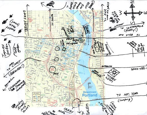
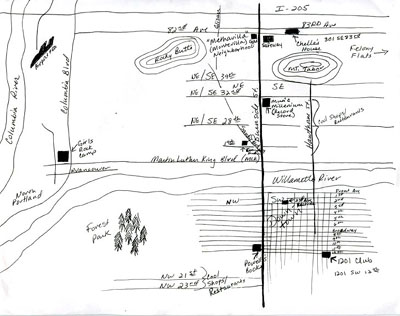
There are certain conventional ways in which we are swayed to orient ourselves, the most common being North as depicted going “up” on the page, with East to the right, and so on. This northern-priority tendency is commonly believed to tie into the compass which pulls toward magnetic North, and reinforced by standard projections which place the Northern Hemisphere of the world as the central focus (an attribute which many believe is a bias and instigator of a superiority complex). This tendency is so strong that nearly all of my maps conform to it. One of the most common written icons in my collection is a variation of a compass rose, with an arrow for North pointing up. There were, however, a few interesting anomalies – my favorites being from Portland, Oregon, created to guide me from the house I was staying at to a camp I volunteered at, Forest Park (“wow!”), downtown, and other places of interest.
(article continued here)