Mapping Empire (Part 1) :: Going home by way of Providence
by Molly Wheelock
To get home I drive down I-95 and exit at New Haven, barely escaping multiple car pile ups and certain death, to drive along the Hudson River and the buggy, muggy, but oh-so-green Appalachians. At the exit formerly known as 5, I catch I-90 with a glimpse of Lake Erie and head southwest towards Cleveland. A nice but short breakfast with a friend in the suburbs and it’s south to I-80. Trucks, bill boards, adult mega-wega-ya-hoo-warehouses, Linda Rondstadt, pee stop, Linda louder for a sing-a-long… chasing the sun down a long highway to Nebraska. God, I love how the day gets longer going west! Corn stalks flag me down against the pomegranate sky and direct me to a camp ground on the Colorado border. You can’t drive across the High Plains in the dark because then you miss seeing Pike’s Peak and Long’s Peak emerge from the grains and behind the approaching city. “We’re almost ho-ome!” I sing to the boxes and bags and candy wrappers, driving around the stinky welcome of Denver, the hogbacks stretched out like the guard dogs of the Rockies. Now it’s Pure Prairie League and the Nitty Gritty blasting over the speakers as the moisture and oxygen suck from the air, leaving room to breath. Memories scream by in flashes of schools, homes, creeks, and the ever intruding highway. But I’m home. Taking the long exit ramp, climbing the hill, slowly passing the liquor store, the church, slower, the Dairy King (yes, this is the King of Dairy), and finally, like a drink of mountain water, my wheels turn onto the gravel and up Daley Street to Sunny Avenue. On the corner is my parents’ house, stark logs bake in the hard afternoon sun but the cool white interior welcomes the western breeze from the open windows. HOME, Home, home…
But not tonight.
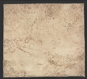
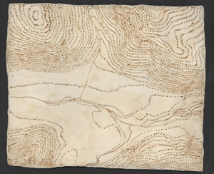
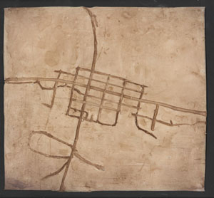
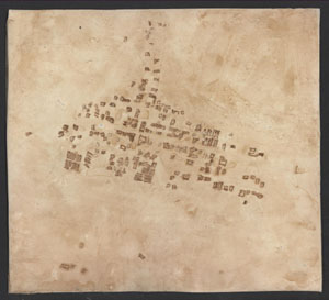
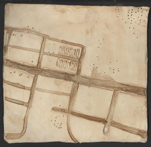
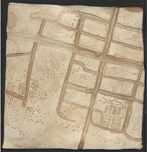
Tonight I am in Providence, another place to love once I leave it. Tonight the warmth of the computer and bright screen beam up at my tired eyes while my truck sits in the drive way, covered in heavy New England snow (and out of gas, to boot!). Home: E-M-P-I-R-E, tab, C-O, return… stares back at me in my choice of bright green topography map or grey scale aerial photograph. New layers of meaning emerge and Empire becomes something different to me: big fat lines intersected by the smaller loopy and curvy ones; little houses I squash with my scribe; tiny hiker feet following the topo lines; trailer park popsicles.
Little Empires all along my wall wait for the spring and
the caress of the road to take them home to the Big Mama Empire (really more
of a cute little mamasita). I wait, too, tracing my hikes, poking the corner
next to the gas station, wondering what my mamasita is doing down there in
that tiny house…
Being home, I guess.
Mapping Empire is a series of exercises in the representation of my home town - based on memory, speculation, and the question of “is vernacular alive (or dead)”.