-PROVFLUX ARTIST-
Mapsproject
by Lori Ann Napoleon
The conventional function of a map is to contain universal symbols and keys; icons that people will recognize as streets, monuments, etc. As in organized tours, they emphasize what is commonly thought of as interesting and important.
I collect personal maps people draw. One’s memory and perception of a place is very personal, so each is a reflection, however small or large, of how the individual connects to their environment: knowing, organizing, and understanding it. In short, each one is a small token of memory and experience, whether created in order to help me understand a place, to direct me to the nearest gas station, or as an answer to my persistent requests to find the local gem of a strange little town.
The original goal of the project was to view each map as
a portrait of the individual who created it; whether they meticulously add
every picketed railroad line and stop sign, or quickly dash a couple of quick
marks across the page and hand it to me with a bashful smile and comment:
“This is a real work of art, eh?”
Jim Warfield, the creator of my map of tiny Mount Carroll, Illinois, comments
that he sees the maps as “a psychological profile of how they [the mapmakers]
see themselves and their “place” in this world (usually as defined
by everyone else)."
“You live in a small house, you must not be important.”
“You live in a concrete drainage tunnel under the highway, you will be important as the world comes to an end, everyone will be seeking YOUR knowledge of how to live like that!”
In the act of assembling over 4 years’ worth of maps together, I have discovered a new dimension to the piece: a very personal account of the places I’ve been, and the people who I have encountered while navigating through many environments. In an attempt to study the maps solely as personifications of their creators, I have discovered a greater portrait of myself: commonalities in the types of places I seek out, and documentation of the locations and people who have touched my life in varying degrees. Certain examples have stood out to me as my favorites:
Ballyvaughan, Ireland: This map was composed over a year after I’d lived there, in a quickly scrawled out attempt to describe the experience to a friend of mine. All of this was based purely on my memory of the place, so it was interesting to revisit it again, 3 years after I made the map and 4 years after living there, to see how my memory of the town was in the process of decaying. I was surprised to see the various details I’d pointed out on the map that I’d since forgotten, such as a meditation shed that I drew in back of a local acquaintance’s house, or the swing set in front. If I were asked to compose a map of Ballyvaughan this year, I’d certainly have omitted precious details like that. In this way, this project also serves as a means of preserving the types of experiences that often fade away from our memories.
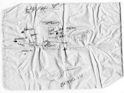
New York City, New York: Self-consciously entitled, “Bad Map,” this one was created by a friend of mine on a napkin, which automatically evokes the spontaneity of the situation in which it was made (on the only readily available surface.) Although this delicate and ethereal map may look confusing to navigate, one quality that is inherent to handmade maps is the narration that takes place every time a new mark is drawn; the animated gestures and explanation which accompany the physical drawing of it. Like all of the maps, it carries within it the conversation that took place at the specific location it was created at, so this “Bad Map” map indeed made sense at the time.
Somewhere in the French Alps: This cryptic map was drawn by a very friendly waiter on the stationary of his Alpine restaurant in a small spa town. The object of the excursion was to simply drive to places that people highlighted on their personal maps, in an attempt to discover spots that the locals deemed important as opposed to standard tourist information. The results were many spirited conversations with townspeople who were generous and proud to share their unique knowledge of the environments they knew best.
I have always been the type of person who documents every precious, seemingly insignificant moment. Conventional maps, travel guides, and the Internet contain such a vast amount of information, one could easily assume that there has not been one square foot of land that has not already been discovered and documented. This could not be farther from the truth, and strictly depending on such readily available information can serve to hinder one from seeking his/her own personal discoveries. My collection is an attempt to preserve and celebrate the people and places that I have encountered via each person’s unique perspective, and to discover that, however fragmented and transient many people may find their lives, a close examination of the places to which one connects is a keen and telling guide towards a true discovery and understanding of oneself.
Lori Napoleon’s maps can be seen at the Steelyard during the Provflux.
You can also view and read more about her collection of maps at www.subk.net/maps.html.